Interlaken
Hike Up Brienzer Rothorn: 1,782 m From the Lake
T
Timoté Baily
Author
September 2, 2026
16 min
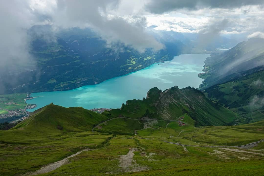
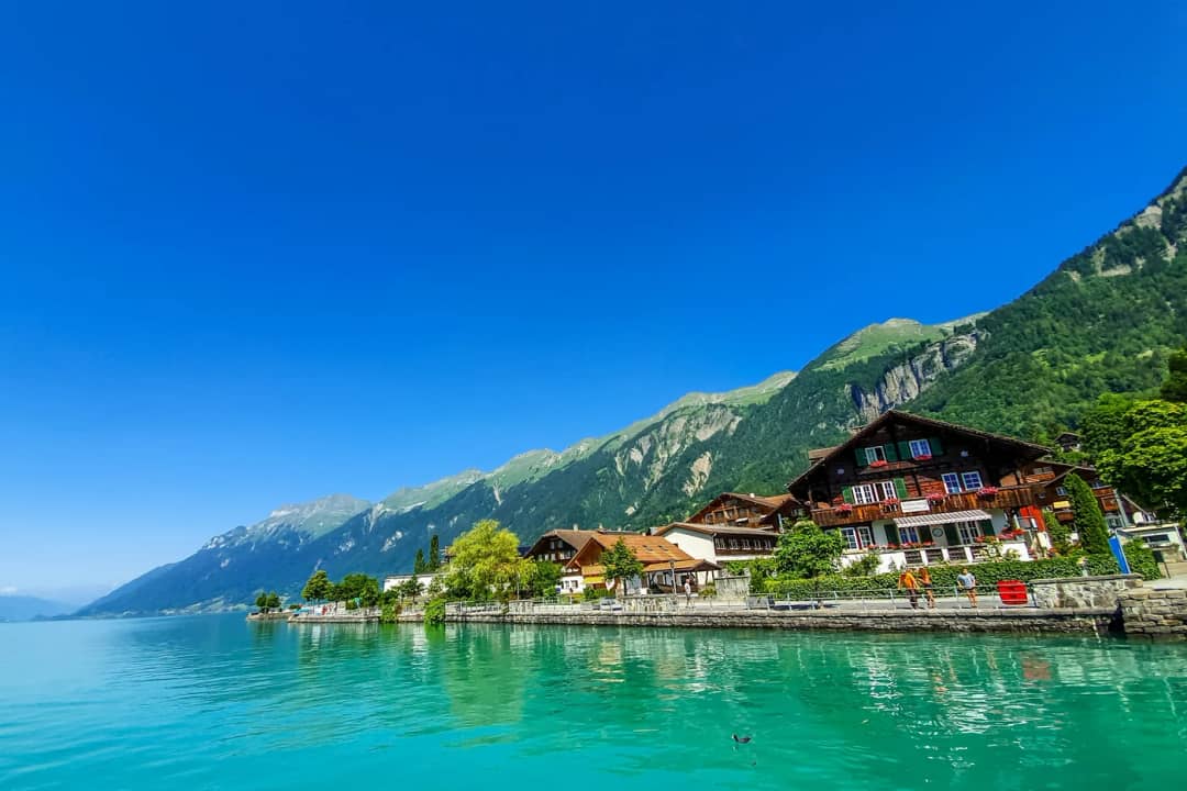
One line sits above everything else on the Brienz Rothorn Railway website, in small grey type that most people scroll straight past. It says the hiking trail from Brienz to Planalp via the Milibachgraben remains closed due to severe weather.
That line has been true since the evening of 12 August 2024, and it is not a seasonal closure. A thunderstorm turned the Milibach into a debris flow, tore out two bridges and cut the streambed so deep that the path cannot be rebuilt where it was. The federal hiking closure register still lists it today as closed until further notice.
So can you walk up the Brienzer Rothorn instead of paying CHF 98 for the steam train? Not a clean yes. It is 1,782 metres from the platform at Brienz to the summit cross at 2,348 m. That makes it one of the biggest single climbs from a lakeside railway station in Switzerland. But the path the maps and blogs still show is closed, and the register lists the detour as closed too.
Here is what the federal register lists as closed, what the day costs and what it asks of your legs. Then the one deadline that decides whether it works.
Can you still hike up the Brienzer Rothorn from Brienz?
Not on the usual line. The historic Milibach path was destroyed by a debris flow on 12 August 2024 and is closed until further notice. Interlaken Tourismus describes a detour via the Trachtbach and up to Gäldried. The federal hiking closure register lists the Gäldried section as closed too, duration unknown, as read on 13 September 2026. Treat it as closed.
The confusion is not your fault. Three official pages say three different things right now, and I checked all three on 30 August 2026.
The railway puts the closure banner at the top of its hiking page, worded around the Milibachgraben. Read quickly, it sounds like the whole ascent is shut.
The federal hiking closure register at map.geo.admin.ch, fed by the Swiss Hiking Federation and the cantonal associations, carries three validated entries, all with the reason "Storm damage". Two are titled Brienz Milibach and marked "Closure with detour", duration "until further notice". The third, 899 metres long, is titled Brienz Gäldried and marked "Closure", duration "unknown". All three read: "The hiking trail is not passable due to storm damage. The path and bridges were torn away by the masses of water."
And Interlaken Tourismus, in its own route database, contradicts itself. Its route Brienz - Gäldried - Planalp is flagged "This route passes through an inaccessible area and is therefore closed." Its route Hike to the Brienzer Rothorn, covering the same ground and more, is not flagged, and its description says plainly that a mudslide in August 2024 closed the original Milibach stream trail and that hikers must use an alternative route via Trachtbach toward Gäldried.
Both entries belong to the same publisher. Both were live this morning. Which of the two reflects the path today has to be checked on the ground.
What happened to the detour via Gäldried?
On paper, the detour leaves Brienz on the other side of the stream and climbs via Trachtbach to Gäldried. It rejoins the main track below Planalp. The federal register lists its Gäldried section as closed. These three lengths come from the federal geodata service, read on 30 August 2026, because nobody publishes the numbers.
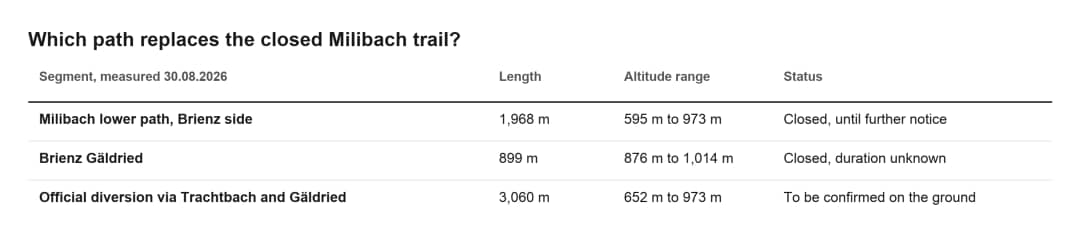
Read that table twice. The diversion is 3,060 metres of walking to replace 1,968 metres of destroyed path. On paper you walk roughly 1.1 kilometres further for the same 320 metres of climb. In total 2,867 metres of hiking trail on this mountainside are closed.
The old line will not come back. Two bridges over the Milibach were swept away and cannot be replaced, and the streambed eroded too deeply for a path in the same place. What is being built instead is a flood protection project for the village, not a footpath.
How much climbing is it, and why does every source give a different number?
Between 1,702 and 1,873 metres, depending on who you ask and where they stop counting. That spread of 171 metres is real, and it exists because the sources end at different points: some at the railway terminus, some at the summit cross, one at the bottom of the return leg.
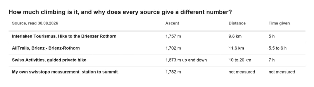
The arithmetic behind the last line is simple and you can check it. Brienz station sits at 566.3 m on the federal elevation model, and the municipality's own figures agree at 566.5 m. The federal elevation model puts the Brienzer Rothorn summit at 2,348.0 m; the railway gives 2,350 m. Subtract, and you get 1,781.7 metres.
If you stop at the railway terminus rather than walking the last stretch, the railway puts that station at 2,244 m, which makes the climb 1,678 m. The Berghaus itself stands slightly higher, at 2,263 m.
Interlaken Tourismus rates the route "difficult", and the fitness it requires "very difficult". The railway notes that the routes around the Rothorn are red and white marked mountain paths, and its own wording is worth keeping in your head: "Hikes in the Rothorn area are not walks and are at your own risk."
How fit do you need to be for 1,782 metres?
Fit enough to climb for five to six hours without a rest day afterwards. There is no flat section, no cable car bail-out, and above Planalp there is no shade at all. Most people who turn back do so in the second half, on the open meadows, in the sun, with 900 metres still to go.
My own estimate for the whole climb is about four hours. Interlaken Tourismus gives 5 hours for its route of 9.8 km and 1,757 metres.
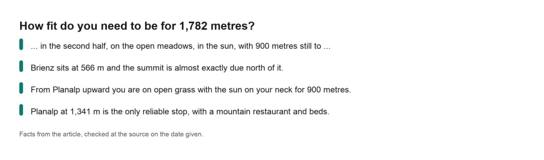
Three things decide this hike, and none of them is the technical grade.
The aspect. Brienz sits at 566 m and the summit is almost exactly due north of it. You spend the whole day climbing a south-facing flank, which is why the snow leaves it early and why it bakes in July and August. The lower half runs through forest and gives you shade. From Planalp upward you are on open grass with the sun on your neck for 900 metres.
The water. Planalp at 1,341 m is the only reliable stop, with a mountain restaurant and beds. Above it you carry what you drink. That is roughly the halfway point by height, and it is the last time anyone will sell you anything until the summit.
The deadline. The last train down from Rothorn Kulm leaves at 17:40, and the one before it goes at 16:28. Work backwards through five to six hours of climbing plus stops, and a 09:00 start from Brienz is comfortable, a 10:30 start is tight, and anything later means you should plan to walk down as well.
That last point is the one the route databases do not model. A route card that says "5 h" is measuring moving time on a good day, and it has never met your knees at hour four.
If any of this reads as too much, the honest split is below. Nobody hands out medals at the top, and the mountain does not know whether you rode the first 775 metres.
What does it cost to walk up and ride down?
CHF 63.00 for an adult, which is the one-way fare in either direction, against CHF 98.00 for the return. Walking up and riding down therefore saves CHF 35.00, and the saving is bigger in proportion for anyone with a Half Fare card. All fares below come from the railway's own 2026 price page, read on 30 August 2026.
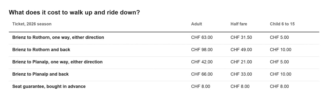
Now the part that is not on the price page, and that matters far more to someone arriving on foot.
A downhill seat is not something you can count on. The railway sells a seat guarantee, but it is bought in advance and the seats are not numbered. On busy days the whole railway sells out, and the homepage carries a banner reading FULLY BOOKED TODAY. I saw that banner up on 29 August at 19:25 and again when I checked the site on 30 August, two days running at the end of a normal August week.
If you have just climbed 1,782 metres and the train is full, your options are the Berghaus for the night or 1,782 metres of descent on tired legs. Descending that much hurts more than climbing it, and it is the reason the split options below exist.
Buy the downhill leg before you start walking if you can, and if you cannot, treat the overnight as your plan B rather than your disaster.
The downhill departures from Rothorn Kulm in the 2026 season are 09:06, 09:38, 11:15, 12:20, 13:28, 14:28, 15:28, 16:28 and 17:40, with the 09:06 running only on Saturdays and Sundays in July, August and September. Note the gap: after 16:28 you wait 72 minutes for the last one. Note also that the final uphill train arrives at 17:31, nine minutes before the last one leaves, which tells you exactly how much of an afterthought the evening is on this line.
Should you split it at Planalp, or sleep at the top?
Three sensible shapes for this mountain, and only one of them is the full climb. Pick by how much of the day you want to spend going uphill and whether you want to be on the summit at an hour when nobody else is.
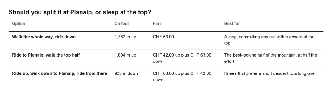
The middle option is the one I would push hardest. Planalp to the summit is where the mountain actually opens up. The treeline falls away, the lake goes turquoise below you, and the Tannhorn ridge comes into view. The forest section you skip is pleasant. It is also the part the federal register lists as closed.
And then there is the version that makes the whole climb make sense. The Berghaus Rothorn Kulm takes guests overnight, from CHF 82 to CHF 160 per person depending on the room, with children from 2 to 15 at CHF 41 to 61, tourist tax on top. There are double rooms, family rooms and multi-bed rooms with six or eight bunks. The railway's own shop sells a voucher at CHF 290.00 for one night for two people in a double room including dinner, and it says outright that the travel is not included and that you can combine it with "your hike".
Walk up in the afternoon, eat at 2,263 metres, and have the summit to yourself until the first train of the day gets there. That arrival is 08:36 on Saturdays and Sundays in July, August and September and 09:31 on every other day, so a sunrise up there belongs to whoever slept in the building. It is the only way to stand on that summit without a hundred other people.
"My own way on this mountain: the train up, and on foot back down."
Timoté Baily, mountain photographer at Swiss Local Adventures
The railway sells the one-way ride at CHF 63.00 for an adult. Below Planalp, the federal register lists both the Milibach path and the Gäldried detour as closed.
When can you walk it, and what closes the mountain?
The trail is walkable from roughly late spring to the first lasting snow, but the railway runs to the summit only from 6 June to 25 October 2026. From 9 May to 5 June it runs as far as Planalp, and outside those dates there is no ride down at all. Four separate things close this mountain, and only one of them is obvious.
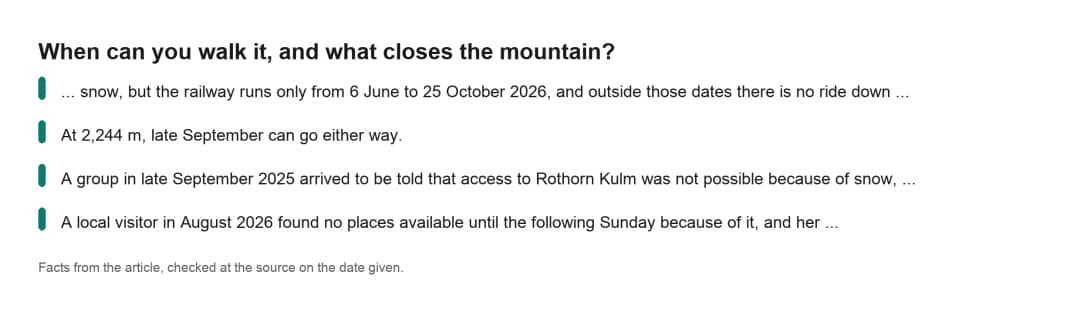
Snow. At 2,244 m, late September can go either way. A group in late September 2025 arrived to be told that access to Rothorn Kulm was not possible because of snow, and got only the Planalp section.
Sold-out days. August fills the railway completely, which matters to walkers only in one direction, downhill, but that is the direction you will want.
Fire risk. A steam locomotive in a dry summer is a fire hazard, and the line has closed for exactly that reason. A local visitor in August 2026 found no places available until the following Sunday because of it, and her complaint was not the closure but the silence: nothing about it was readable online.
Weather on the ridge. The train is a timetable, not a rescue service. Carry your own weather plan, and check the railway's homepage the morning you go rather than any aggregator, because these banners change by the hour.
For the safety basics, the railway points walkers at sicher-bergwandern.ch, published by the Swiss accident prevention agency BFU with Schweizer Wanderwege. It is worth two minutes before a 1,782 metre day.
Your questions about hiking up the Brienzer Rothorn
How long does it take to hike up the Brienzer Rothorn from Brienz?
Between five and six hours of moving time for the full ascent, plus stops. Interlaken Tourismus gives 5 hours for 9.8 km and 1,757 m. AllTrails gives 5.5 to 6 hours for 11.6 km and 1,702 m. A guided operator selling the round trip on foot budgets 7 hours for 1,873 m up and down. Add an hour for lunch at Planalp and photographs above the treeline, and a realistic door-to-summit figure from a 09:00 start is early afternoon. The last train down leaves Rothorn Kulm at 17:40, so build your day backwards from that.
Is the Brienz to Planalp hiking trail open in 2026?
No, according to the federal hiking closure register, read on 13 September 2026. The historic path through the Milibachgraben is closed until further notice after the debris flow of 12 August 2024. It will not be rebuilt: two bridges were swept away and the streambed eroded too deeply. The register also lists the Gäldried section of the detour as closed, duration unknown. Interlaken Tourismus flags its Brienz - Gäldried - Planalp route as closed too. Its Hike to the Brienzer Rothorn route, over the same ground, still describes the detour.
How much does it cost to hike up and take the train down?
CHF 63.00 for an adult, CHF 31.50 with a Half Fare card, CHF 5.00 for a child aged 6 to 15. That is the one-way fare, and the railway confirms it applies in both directions. The return ticket costs CHF 98.00, so walking one leg saves CHF 35.00. A seat guarantee costs CHF 8.00 extra when bought in advance, and it is worth having for the descent because the railway does sell out completely on busy summer days.
Is the Brienzer Rothorn hike hard?
Interlaken Tourismus rates it "difficult" on a red and white marked mountain path, and the difficulty here is endurance rather than technique. 1,782 metres of continuous ascent with no flat ground, on a south-facing slope with no shade above 1,341 m, is a serious day. AllTrails rates both local variants "Hard". If in doubt, ride to Planalp and walk the upper 1,007 metres instead, which is the better-looking half anyway.
Can you stay overnight at the top of the Brienzer Rothorn?
Yes. The Berghaus Rothorn Kulm at 2,263 m takes guests in double, family and multi-bed rooms with six or eight bunks, from CHF 82 to CHF 160 per person, children 2 to 15 from CHF 41 to 61, tourist tax extra. Book on +41 33 951 12 21 or berghaus@brb.ch. For anyone walking up, it removes the 17:40 deadline entirely and gives you the summit to yourself until the first train of the day arrives, at 08:36 on Saturdays and Sundays in July, August and September and 09:31 otherwise.
Is there water on the way up the Brienzer Rothorn?
Planalp at 1,341 m has a mountain restaurant and is the only reliable stop on the way, roughly halfway by height. Above it you carry what you drink, on open grass with no shade for 900 metres of climb.
What can you see from the top?
The railway claims 693 mountain peaks on a clear day, from Pilatus, the Rigi and the Titlis across the Eiger, Mönch and Jungfrau to the Chasseral in the Jura. That number is the operator's own and it is oddly precise, which is why it is worth quoting rather than rounding. The railway puts the summit trail from its terminus at about 15 minutes.
Start early, and buy the ride down before you leave
If you take one thing from all of this, make it the ticket. Buy the one-way downhill leg at the Brienz counter before you start walking, at CHF 63.00, and the whole day stops being a gamble on whether the 17:40 has room for you.
Then check the federal closure register on the morning you go. On 13 September 2026 it listed the Milibach path and the Gäldried detour as closed. Treat Planalp as the point where you decide honestly whether the second half is in your legs today. There is no shame in the CHF 42.00 ticket from there.
If this mountain is one day of a longer stay, our best day trips from Interlaken, our best outdoor adventures in Interlaken and summer in Interlaken show what fits around it. For a local's short list, see things to do in Interlaken.
If you are building a week around Interlaken and want to know which morning is right for this mountain, we can plan a private day around it, or message us on WhatsApp.
Source: Brienz Rothorn Bahn timetable and prices, Brienz Rothorn Bahn hiking page, Interlaken Tourismus route "Hike to the Brienzer Rothorn", the federal hiking closure register at map.geo.admin.ch and sicher-bergwandern.ch, all read on 30 August 2026, with elevations from the swisstopo federal elevation model.
Written by Timoté Baily, your mountain photographer at Swiss Local Adventures
Tags
#mountain-hiking#summit-hikes#cogwheel-railways#hiking-trail-closures#lake-brienz-day-trip#interlaken-outdoor-adventures
Sources & References
- •Brienz Rothorn Bahn, timetable and prices 2026
- •Brienz Rothorn Bahn, hiking
- •Brienz Rothorn Bahn, mountain hotel Rothorn Kulm
- •Brienz Rothorn Bahn, questions and answers
- •Interlaken Tourismus, Hike to the Brienzer Rothorn
- •Federal register of hiking trail closures, map.geo.admin.ch
- •BFU, sicher-bergwandern.ch
- •Municipality of Brienz, figures
- •Photo: Josef Ivan Jimenea on Unsplash
- •Photo: Andreas M on Unsplash